


New Zealand Topo Maps
Perihal New Zealand Topo Maps
Aplikasi navigasi luaran yang mudah digunakan dengan peta topografi terkini dari New Zealand, Kepulauan Cook dan Tokelau.
Aplikasi ini memberi anda pilihan pemetaan yang serupa seperti yang mungkin anda ketahui dari telefon bimbit GPS Garmin atau Magellan.
Ciri-ciri utama untuk navigasi luar:
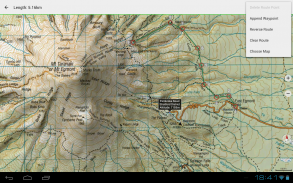
• Buat dan edit Titik Jalan
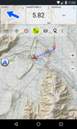
• Navigasi GoTo-Waypoint
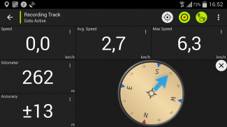
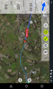
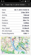
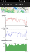
• Rakaman Trek (dengan profil kelajuan, ketinggian dan ketepatan)
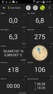
• Tripmaster dengan medan untuk odometer, kelajuan rata-rata, galas, ketinggian, dll.
• GPX-Import / Export, KML-Export
• Cari (nama tempat, POI, jalan)
• Medan data yang dapat disesuaikan dalam Peta Lihat dan Tripmaster (mis. Kelajuan, Jarak, Kompas, ...)
• Kongsi Titik Jalan, Lintasan atau Laluan (melalui eMail, Facebook, ..)
• Gunakan Koordinat di UTM, WGS84 atau MGRS
• dan banyak lagi ...
Lapisan peta asas yang ada:
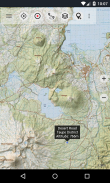
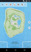
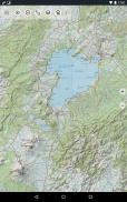
• Topomaps New Zealand (liputan lancar pada skala 1: 250.000 dan 1: 50.000)
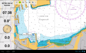
• NZMariner (Carta Nautikal RNC)
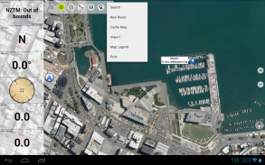
• Citra Udara LINZ
• Peta Google (Gambar satelit, Peta Jalan dan Medan)
• Buka Peta Jalan
• Peta Bing
• Peta ESRI
Lapisan lapisan:
• Kawasan Pemuliharaan Awam
• Kawasan Memburu Terbuka
• Tapak Kem DOC
• Sekatan Perkhemahan DOC Freedom
• DOC Huts
• Trek DOC
• Daerah Perikanan Taupo Trout
• Hillshading
Gunakan aplikasi navigasi ini untuk aktiviti luar seperti mendaki, berbasikal, berkhemah, mendaki, menunggang, bermain ski, berkanu atau lawatan 4WD di luar jalan.
Pramuat data peta PERCUMA untuk kawasan tanpa perkhidmatan sel. (Versi Pro sahaja)
TERHAD VERSI PERCUMA:
• Iklan
• Maks. 3 Titik Jalan
• Maks. 3 Lintasan
• Tiada Laluan
• Tiada import titik jalan dan trek
• Tiada Beban Pukal
• Tiada DB Bandar Tempatan (Carian Luar Talian)
Peta topografi dibuat oleh Land Information New Zealand (LINZ).
Topo50 adalah siri peta topografi rasmi yang digunakan oleh perkhidmatan kecemasan New Zealand.
Bagaimana maklumat topografi digunakan
Perancangan pertahanan: Pasukan pertahanan New Zealand menggunakan maklumat topografi untuk merancang latihan ketenteraan dan menukar maklumat dengan rakan antarabangsa.
Lokasi dan laluan: Pencarian dan Penyelamatan, pertahanan, ambulans, bomba, polis dan agensi pertahanan awam menggunakan maklumat topografi dalam pelbagai situasi perancangan dan operasi, dari bencana alam hingga kepolisian masyarakat. Penggunaan mungkin melibatkan situasi bilik bergerak / lapangan dan kawalan, dan gabungan maklumat topografi dengan data lain.
Pengurusan tanah: Maklumat topografi digunakan oleh pemerintah daerah untuk perencanaan dan operasi wilayah, dan oleh syarikat tenaga, gas dan telekomunikasi.
Di samping itu, peta LINZ digunakan untuk pelbagai tujuan oleh perniagaan dan jabatan kerajaan seperti Jabatan Pemuliharaan, dan oleh pengguna rekreasi seperti trampers dan pelancong.
Semua peta topografi mempunyai label tambahan untuk pembacaan yang lebih baik pada skala zoom yang lebih tinggi. Peta dibuat dengan pelindung bukit Atlogis® untuk meningkatkan topografi.
Liputan Peta Topo:
New Zealand and Islands (Antipodes, Auckland, Bounty, Campbell, Chatham, Kermadec, Raoul, Snares dan Stewart Islands) pada skala 1: 50.000 dan 1: 250.000
Kepulauan Cook (Aitutaki, Atiu, Mangaia, Manihiki, Mauke, Mitiaro, Palmerston, Penrhyn, Pukapuka, Rakahanga, Rarotonga, Suwarrow, Takute) pada skala 1: 25.000
Kepulauan Tokelau (Atafu, Nukunonu, Fakaofo) pada skala 1: 25.000
Sila hantarkan komen dan permintaan ciri ke nzmaps@atlogis.com
New Zealand Topo Maps - Versi 7.8.3
(10-07-2025)New Zealand Topo Maps - Maklumat APK
Versi APK: 7.8.3Pakej: com.atlogis.nzmaps.freeVersi Terkini New Zealand Topo Maps
Versi lain


Aplikasi dalam kategori sama

Anda juga mungkin suka...


